THE MOST AWE-INSPIRING GHOST TOWN IN MISSOURI isn’t a ghost town at all. It checks most of the boxes, sure. It’s barely inhabited, positioned along Route 66, and contains its own cemetery—a rural fossil of another era—but it was never exactly abandoned. In fact, it’s still peaking.
Red Oak II sits northeast of Carthage, and describing it accurately requires effort. It’s an old-fashioned country settlement, an art installation, and a roadside attraction. It could be succinctly called an outdoor ghost town museum. Don’t worry, this will all make sense in a moment.
In 1974, artist Lowell Davis left his big-city job in Dallas to return to the bucolic southwestern Missouri landscape where he was raised. He and his first wife bought a rundown farm near Carthage for $18,000 with no expectation of what would happen next.
Davis was raised in the small community of Red Oak, about 20 miles east of the new farm. When he stopped by his childhood township to reminisce, he found it deserted, a victim of widespread 20th-century migrations to larger cities. And Red Oak wasn’t the only ghost town he came across. Many settlements along Route 66 had been abandoned while he was away, their buildings withering and stories fading into the countryside.
Unwilling to let history die, Davis began moving some of these marooned structures to his farm and restoring them—some from Red Oak, some from nearby. Using his cornfield as an unlikely canvas, Davis grew his collection. Soon, he realized he was onto something incredible.
Lowell Davis’ early restorations included (from left to right) the Red Oak General Store, Phillips 66 Gas Station, Salem Church, Belle Starr House, and Grandpa Weber’s Blacksmith Shop. | PHOTO COURTESY OF RED OAK II
Davis’ farm slowly became its own miniature city, which he dubbed Red Oak II. Here, fragments of nearby ghost towns would be immortalized together in an ever-evolving collection.
“I don’t believe that an artist should be restricted to use only paint or clay. It can be anything including junk, wood, even an old building,” Davis wrote on the attraction’s website. “To me, Red Oak II is a combination of a painting and a sculpture, and it is just made from things that someone else threw away.”
Among the early additions to Red Oak II were particularly sentimental pieces of Davis’ youth: the Red Oak General Store—formerly run by his father, and where the young Davis learned to sculpt and paint—and Grandpa Weber’s Blacksmith Shop, where his own great-grandfather worked.
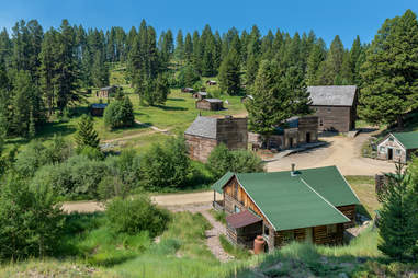
Today, Red Oak II is a full-blown faux town owned and operated by Davis, his wife, Rose, and a few neighbors. Encompassing 11 acres of land, the town itself has a population of 12.
A building trucked over from the original Red Oak became a town hall for Red Oak II. | NICK FOX/SHUTTERSTOCK
One of the current part-owners is Larry Sernyk, who bought a stake in the project in 2004 after finding Davis through his art. Now a good friend of the Davises with a seasoned understanding of the founder’s philosophy, Sernyk has plans to keep growing Red Oak II—and a whole pasture to develop on should they ever run out of space.
Despite housing private residences, the Red Oak II grounds are open to the public from dawn till dusk. Some structures—like the General Store, Fort Hooker, and a cabin on the lake—can be toured inside and out, while others are admired solely from the outside. Once Sernyk, who currently lives out of state, retires at Red Oak II, he plans to furnish the train station as well.
Even buildings that are closed to the public are worth passing through to see. While Davis’ primary goal was to maintain the buildings’ integrity, he’s taken a few creative liberties.
“Red Oak II is trying to preserve the past, so [Davis] always tried to keep the character of the building as true as possible,” says Sernyk.
But Davis—who could not speak to Thrillist due to health reasons—believes that art happens when you break straight lines. Imperfections are welcome. So too are color changes, resulting in a bright landscape that’s equal parts rustic and refined.
“Those might not be the original colors, but they do add some character,” says Sernyk. “They make it into Lowell’s art.”
Davis’ other art, which includes handmade sculptures and smaller structures like a windmill and water tower, can be seen by touring the grounds on foot. In the next couple of years, one of the property owners plans to add a rideable train to the development so visitors can ride around the property via locomotive. He already acquired a railroad track from an amusement park.
“There’s places where they have living history, where people [re-enact] things from the era. We don’t really do that part,” Sernyk says. Red Oak II doesn’t need costumes or shows to paint a vivid picture of days gone by. Its history is its present. “I look at it as going back to the past.”
NYC is gorgeous. Period. Its skyscrapers, bridges, islands, and rivers are in leagues of their own, and for a so-called concrete jungle, there’s a shocking amount of green space where you can take it all in. Central Park and Prospect Park are the most obvious options for an outdoor day, but nothing beats a park along the water, where cool breezes and skyline views complete the experience.
With 520 miles of shore, the city has seemingly endless waterfronts to explore in every borough, yet people still fall back on spots like Brooklyn Bridge Park in DUMBO, and Riverside Park in the UWS, and Domino Park in Williamsburg — and don’t even get us started on the chaos that is Pier 45 in the West Village.
Luckily there are plenty of lesser-known NYC waterfront areas worthy of your attention. If you’re not adding these underappreciated — and, frankly, under-respected — waterfront parks to your destination rotation, it’s time to diversify your outdoor routine. And that’s the tea.
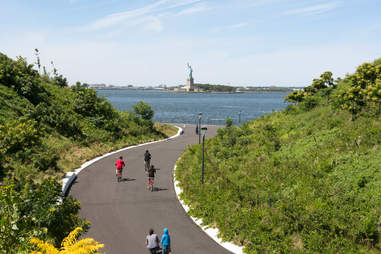
Governors Island The artificial hills on this artificial chunk of island are genuinely amazing. Spanning only 10 acres, the expertly engineered outdoor space makes for a remarkable day trip. Roam Discovery Hill, a 40-foot-tall mound with trees, shrubs, and a permanent art installation; climb Outlook Hill, a 70-foot-tall lookout spot with unbridled views of Lower Manhattan, the Statue of Liberty, and the Verrazzano Bridge; and ride NYC’s longest slide (57 feet long and three stories high!) on Slide Hill. When you’re ready to get off your feet, lie out on Grassy Hill, a slightly smaller hump with an equally breathtaking vantage point.
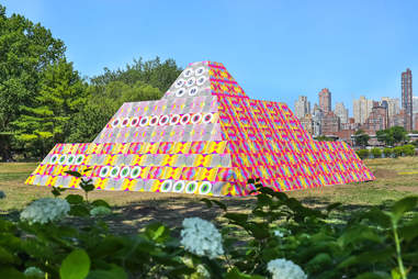
Astoria Rotating art installations transform this ordinary neighborhood park into an alluring spectacle in Queens by the East River and near the north end of Roosevelt Island. Even without the sculptures, though, the one-block-long landfill-turned-green space is worthy of a visit. There’s a grove of trees, pockets of plants, and open lawn space that make circling the perimeter of the park a pleasant experience. Plus, it sits between a Costco and a miniature beach. Talk about range.
Hell Gate Wildflower Meadow | COURTESY OF THE RANDALL’S ISLAND PARK ALLIANCE
Randall’s Island You probably associate Randall’s and Wards Islands with athletic fields and music festivals, but you don’t need an event to make visiting worth your while. The island’s gardens dress up an already scenic chunk of land, and one of its best is the 14,000-square-foot meadow beside the Hell Gate Bridge that’s known for its several species of native Northeast plants. Look out at Astoria beyond the East River as you breathe in fresh oxygen, and think about all the sorry New Yorkers who will never experience such serenity.
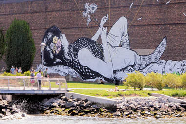
Greenpoint North Brooklyn knows it well, but to people who don’t frequent the area, the former radio transmitter site makes a stellar first impression as an urban oasis tucked behind an unsuspecting fence at the end of Greenpoint Avenue. Walk out on the dock to look out at Manhattan, claim a bench to read on, take a picture in front of the mural, or pop a squat on the ground along the East River shore. The space isn’t huge, but it’s big enough, and it fosters a neighborly feel that’ll make every fellow park-goer seem like an old friend.
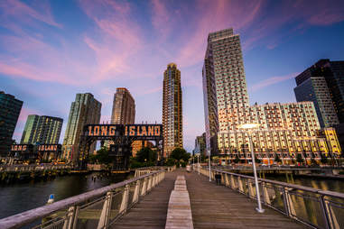
Long Island City Easily one of NYC’s best waterfronts, Gantry Plaza (and it’s neighbor, Hunter’s Point South) boasts unobstructed views of the Manhattan skyline — and plenty of spots to enjoy them, including benches of every shape and size, built-in lounge chairs that double as a lovers’ lane at dusk, and picnic tables beside the park restaurant. The famed Pepsi-Cola sign and restored gantries that read “Long Island” tastefully nod to the neighborhood’s industrial past. It’s a beautiful reading place, a romantic date spot, a calming breakup spot, and the perfect area for a grassy picnic, whether that’s in the mid-afternoon or after dark.
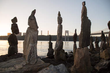
Washington Heights The fun doesn’t stop where Riverside Park ends; just north is a whole new territory to explore. Of course, there are the usual sports fields typical of most hotspots along the Hudson River Greenway, but there are also some unique sights that only Fort Washington Park can offer. Beneath the George Washington Bridge rests Manhattan’s only surviving lighthouse, and the fan-favorite Sisyphus Stones by artist Uliks Gryka provide peaceful environs to meditate and look out at the scenic bluffs of the Palisades.
North Shore Esplanade | MACIEJ BLEDOWSKI/SHUTTERSTOCK
St. George You should know by now that Staten Island has beautiful beaches, but if you don’t want to venture too far down the island, there’s a plaza near the ferry with stellar views of the New York Harbor and One World Trade. The best lookout point is at the Staten Island 9/11 Memorial (aka “Postcards”), which was intentionally positioned to frame the piece of NYC’s skyline where the Twin Towers once stood. The North Shore Esplanade is a little more gray and a little less green than some other local waterfronts, but it’s no less serene.
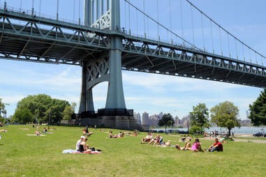
Astoria This enormous waterfront area isn’t exactly Queens’ best-kept secret, but it is a place that other boroughs foolishly overlook. Astoria Park has everything you’d hope for in an NYC gathering place: wide-open lawns, skyline views, a track and field, fourteen tennis courts, bocce courts, basketball courts, a skatepark, a mixed-use path, the city’s largest swimming pool, public restrooms, and not one but two photogenic bridges — the Triborough and the Hell Gate. It spans nearly 60 acres along the East River in northern Astoria, leaving plenty of space for visitors to sprawl.
Four Freedoms Park | SBWORLDPHOTOGRAPHY/SHUTTERSTOCK
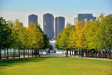
Roosevelt Island Remember Roosevelt Island? You know, that mysterious sliver of land between Manhattan and Queens that you visited for like three minutes when you first moved to NYC because your coworker lied and told you that riding the aerial tram is a rite of passage? Well this state park, located at the base of Roosevelt Island, gives you a good reason to return. Honoring Franklin D. Roosevelt, the tree-lined lawn points to a granite memorial, and the often-photographed staircase at the park’s entrance doubles as a canvas for periodic political exhibits.
East Bronx You thought Central Park was massive? Pelham Bay Park comes in at over three times the size of its Manhattan equivalent, making it NYC’s largest park. Its nearly 2,800 acres include just about everything you can imagine: hiking trails, barbecue areas, playgrounds, every type of athletic field/court/course/track, a historic mansion, a dog run, and 13 miles of shoreline primarily along the Eastchester and Pelham bays. Orchard Beach is the most notable waterfront area — and for good reason — but you don’t need sand to enjoy the area’s many waterways. Just about any of the park’s edges will tickle your fancy, but Hunter Island (which is actually a peninsula) steals the show.
Everyone’s chasing riches in the Land of Opportunity. But when the riches run out, people move on to something newer, shinier, and untapped. It happened to countless boom towns after Gold Rush miners depleted all the gold, and when Gilded Age industrial sites collapsed — and it’s a big reason why the United States was left with so many abandoned towns in the 19th and 20th centuries.
From coast to coast, America’s ghost towns carry the most peculiar backstories. Some began as lucrative mining communities that cleared out almost overnight, and some are casualties of new railways and interstates. Others were once capital cities ravaged by nature and fate. These skeletons of the past could be sets for the next Coen Brothers Western, and at least one has already inspired a chilling horror flick. Hell, some ghost towns are reported to have literal ghosts roaming through the wreckage.
Once bustling with bars, brothels, and bandits, these 14 hamlets are now eerily desolate. You can visit most of them today, but be careful what you touch. Many are so perfectly preserved — furniture, dishes, even beer exactly where it was left — that they feel like dusty time capsules from a century ago.
All that glitters may not be gold, but it can still make you a fortune. Copper lured brave miners to this remote Alaskan spot in the early 1900s after two prospectors stumbled upon what turned out to be $200 million worth of the metal while resting their horses.
They formed what was then called the Utah Copper Company in 1903. Within a few years, and with the help of J.P. Morgan and the Guggenheims, they turned the place into a “self-contained company town,” complete with a tennis court and skating rink. One of Kennecott’s five mines contained the world’s richest copper concentration — they named the claim “Bonanza.” By 1938, however, the copper supply was running low enough that the mines shuttered.
Today, it’s a National Historic Landmark — and one of Alaska’s most popular points of interest — in the heart of the massive Wrangell-St. Elias National Park, which doesn’t charge an entrance fee. The iconic red mill on the hill spans 14 stories above a glacier and can be explored by visitors who take the official Kennecott Mill Town Tour.
There’s still plenty to see in St. Elmo. | FLICKR/TERRA TREKKING
Founded in 1880, St. Elmo was once a highfalutin gold mining town and popular whistle-stop on the Pacific Railroad. It boasted almost 2,000 residents and more than 150 mines — plus enough hotels, brothels, saloons, and dance halls to keep everybody in town happily cutting a rug. When the Alpine Tunnel closed in 1910, however, the music stopped. With the price of silver already down, the last remaining rail service stopped in 1922. The dedicated few that stuck around suffered another loss 30 years later when the postmaster died and postal service was discontinued, further sequestering them from civilization.
Despite numerous fires charring the canyon over the years, St. Elmo remains one of America’s best-preserved ghost towns. Several original structures are still intact, providing an unfiltered glimpse into life during the mining boom (one big exception is the town hall, which had to be rebuilt in 2008 following a particularly destructive blaze). Present-day visitors can tour the old mining roads in ATVs, fish along Chalk Creek, stay in a historic cabin, and shop from a general store that’s open through the summer. Most tourists stop in during warmer months when St. Elmo comes to life, but some prefer to visit in the wintertime when roads and trails are truly abandoned.
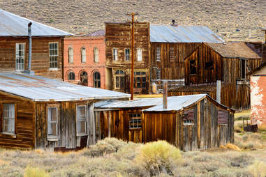
Just like the rest of us, Bodie is in a state of arrested decay. | ZACH FRANK/SHUTTERSTOCK
Like a straight-up Western movie set, Bodie is one of the most famous (and the largest unreconstructed) ghost towns in America. Established in 1859 when William S. Bodey discovered gold in the area, the original camp of around 20 miners mushroomed to some 10,000 during the California Gold Rush — roughly the same population as Los Angeles. By 1880, the town consisted of 2,000 buildings, including roughly 200 restaurants, 70 saloons, and a red-light district. As the gold vanished, though, so did the townsfolk. By 1942, the last mine had shut down.
Today the town is a National Historic Site protected by the California parks system. Buildings are in a state of “arrested decay,” meaning they will only receive necessary maintenance that prevents them from deteriorating and collapsing. Saloons still contain pool tables complete with balls and cues, plus assorted chairs and cutlery, resting exactly where they were left more than half a century ago, and some store shelves remain stocked with goods (no, they’re not for sale). Visitors should be sure to arrive during regular park hours with admission cash in hand; during the summer, guests can take guided tours through the Standard Mill for an inside look at the gold-extraction process.
This Civil War boomtown is flooding with history. | FLICKR/PAT HENSON
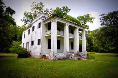
Cahawba has an illustrious history for a ghost town: From 1820 to 1825, it served as Alabama’s state capital before flooding so many times that most of the residents fled for drier pastures (and took the title of capital with them). It remained for years a hub of cotton distribution. During the Civil War, it was home of the Confederate Castle Morgan prison, where thousands of Union soldiers were kept between 1863 and 1865 — when another massive flood started driving people out for good. By the early 1900s, most buildings had been demolished, too.
Still, there’s enough left for history buffs today to enjoy. The welcome center, built in the image of a notable general’s cottage, includes a small museum of artifacts and photos from Cahawba’s peak. Guests can take self-guided tours of the major Civil War sites, the cemetery, and a woodsy nature trail; and no visitor should leave without seeing the Crocheron Columns, the only remaining parts of the Crocheron Mansion where important negotiations were made during the Battle of Selma.
Slinging guns and grabbing cash? It’s all part of the Wild West, baby! | MAGMARCZ/SHUTTERSTOCK
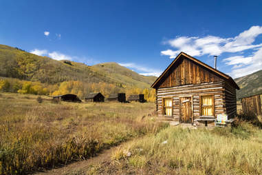
Former home of the famous frontierswoman Calamity Jane, this old gold-mining town (est. 1863) was known for its rough-and-tumble ways. The remote spot didn’t have enough law enforcement or a justice system. As a result, robberies and murders were the norm, and gangs of outlaws known as road agents killed 100 people between 1863 and 1864 alone. Still, Virginia City briefly served as the capital of the Montana Territory (before it was a state), and grew to a population of around 10,000. When gold ran out, though, the city lost momentum and became the Victorian-era time capsule it still is today.
While nearly half of the city’s buildings are originals, they’ve been restored, and the town — which now rocks live music and cabaret shows — is a lively tourist destination. A number of tours provide visitors with whatever experience suits their interests best: Want ghost stories? You’ve got ‘em. Fascinated by trains? There’s a scenic railway for you. Like luxury? Ride in style to the most important historic spots. Prefer novelty? Learn about the town on an old fire truck.
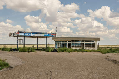
Nobody’s getting their kicks on this stretch of Route 66. | SUE SMITH/SHUTTERSTOCK
Glenrio, Texas/New Mexico
A relic of the legendary Route 66, Glenrio straddles the Texas-New Mexico border, so it’s officially part of both states. This apparently had several benefits: The town’s gas stations were built on the Texas side, where the gas tax was lower, and its bars were wisely built on the New Mexico side, since alcohol sales at the time were illegal in Deaf Smith County, Texas.
The town’s life cycle could’ve been longer. Founded in 1903, it became a popular way station for travelers. When I-40 was built in the early ‘70s and motorists stopped coming through, it withered. This is also the plot of the movie, and fittingly, the town motel makes an (animated) cameo in the movie as a racing museum.
Glenrio has no use now other than to provide passersby with a kick of Route 66 nostalgia. The boarded-up Little Juarez Cafe harks back to the time of Valentine Diners (even though it’s not actually one), and the First in Texas/Last in Texas Motel and Cafe is a fan favorite.
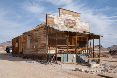
Once upon a time Rhyolite was hot hot hot. | LAURENS HODDENBAGH/SHUTTERSTOCK
Live fast, die young: This Gold Rush town did just that, founded in 1904 and deserted by 1916, despite being the third-largest city in Nevada for a time.
Sitting on the edge of Death Valley, Rhyolite offered residents hotels, a hospital, an opera house and symphony, and even its own stock exchange. Its red-light district was infamous, employing ladies from cosmopolitan locales like San Francisco. But all good things must come to an end, and in Rhyolite’s case, the Panic of 1907 hammered the first nail in the coffin, causing banks to fail, mines to close, and newspapers to shutter. The famed Montgomery Shoshone mine ceased operations in 2011, and any straggling Rhyolites were gone within a few years.
Though it’s been abandoned for almost a century, you can see Rhyolite in a number of old Westerns, including The Air Mail. The town is still known for its many bottle houses, and visitors will still see the skeletons of a three-story bank, part of the old jail, the general store, as well as Rhyolite’s train station. Just outside of town lies another notable attraction: the free and open-to-the-public Goldwell Open Air Museum, perhaps the oddest roadside attraction in a state known for its off-highway weirdness.
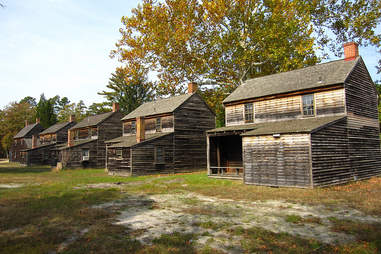
Wait till you see the house Wharton lived in. | FLICKR/CHRIS M MORRIS
With a name derived from the Swedish word batstu (meaning sauna), this Jersey town was once a bustling ironworks that supplied the Continental Army during the Revolutionary War.
Founded in 1766, it was essentially a “company town” owned/run for 92 years by William Richards before its iron and charcoal production were replaced by a mine in Pennsylvania. Industrialist Joseph Wharton (yep, that Wharton) stepped in and bought the town in 1876, experimenting with agriculture and manufacturing before also throwing in the (terrible?) towel to presumably start his little business school in Philadelphia.
Over 40 of the original structures remain today, including Batsto Mansion, a sawmill, a blacksmith, ice and milk houses, a carriage house and stable, and a general store. You can even mail letters at the still-operational post office. The buildings have been fully restored and are maintained as a historical site, with a museum and visitors center.
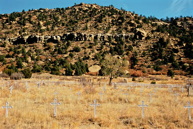
Dawson puts the “ghost” in “ghost town.” | EDUCATION IMAGES/UNIVERSAL IMAGES GROUP/GETTY IMAGES
Every abandoned town has an air of sadness, but none compare to the tragic past of Dawson, New Mexico. What sprouted as a promising company town for Dawson Fuel Co. in 1901 soon became home to a series of devastating decennial explosions in the coal mines: Three lives were lost in 1903, over 250 perished in 1913, and 123 died in 1923. At its peak, Dawson’s population reached numbers around 9,000, mostly recent immigrants from Europe and Mexico; when the 1913 explosion shattered the community, people started moving on.
In the decades that followed these disasters, the demand for coal slowly declined until finally the last mine closed in 1950. The area was sold, most of the structures were demolished, and the few remains of Dawson were left to decay.
Today, this ghost town features more ghosts than town. The only notable landmark left is the Dawson Cemetery, where a sea of white crosses represents the nearly 400 people who died in the mine explosions. Mass casualty sites breed paranormal activity, explaining how the desolate land that once held up Dawson is now one of the most haunted places in America. Visitors have reported seeing lights like those on a mining helmet dancing around, hearing untraceable moans and voices, and coming across ghostly figures that vanish if you get too close. Explore at your own risk.
Minus the fire damage, Garnet’s actually kind of dreamy? | NAGEL PHOTOGRAPHY/SHUTTERSTOCK
Named for the semi-precious red gems prospectors discovered there along with gold, Garnet was inhabited from the 1860s through about 1912, when a fire razed half the town. Since the gold had pretty much run out anyway, there wasn’t much point in rebuilding it. Garnet lasted as long as the mines did; which is to say, not that long. In its heyday, though, the isolated town maintained 13 saloons, four hotels, two barbershops, a doctor’s office, and a school, as well as a daily stagecoach route to nearby towns.
Now, more than 30 historic buildings — a dozen cabins, a store, a saloon, and part of the J.K. Wells Hotel — remain, their interiors practically untouched and still full of dishes, furniture, and clothes. Every June, the town hosts Garnet Day, an afternoon of activities put on for the public, and in the wintertime, there are two rentable cabins on offer. The mountain town was known for its beauty, and its kept-up nature trails continue to impress anyone on the hunt for serenity. More active visitors also enjoy nearby hiking, hunting, fishing, skiing, off-roading, and camping.
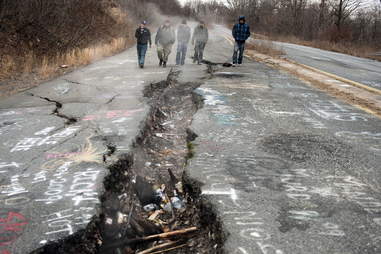
Without the Graffiti Highway, Centralia’s grimmer than ever. | DON EMMERT/GETTY IMAGES
Centralia, Pennsylvania
In the late 1800s, Centralia was a thriving coal-mining town with a population of around 2,700. Technically — technically — Centralia is not a ghost town, since as of 2017 “under five” people live there. However, it makes up for this in eeriness and potential for actual ghosts because Centralia is literally on fire… and has been for decades.
An abandoned coal mine caught fire in 1962, and it’s been smoldering underground ever since. Residents understandably evacuated and the town never recovered. Over time, the population dropped to the handful who remain today. When they die, the state will take their property through eminent domain.
Currently, the town doesn’t even have a zip code, and up until the 2006 horror movieSilent Hillcited Centralia as an inspiration, few people knew the place existed. The coal seen fueling the fire is expected to last another 250 years, and in the meantime there’s not a whole lot visitors can (or should) do there, given the presence of toxic chemicals. People long enjoyed driving four-wheelers down the buckled Graffiti Highway, but property owners covered the landmark with dirt in April 2020 after trespassers flocked to Centralia for joy rides amid the COVID-19 pandemic. For now, Centralia is more of an interesting story than a destination, but there’s truly no telling how the future of this mostly abandoned town will unfold.
Ashcroft just didn’t have the range. | JANIS MALECKIS/SHUTTERSTOCK
Upon discovering silver in 1880, two prospectors eager to make a quick buck created a Miner’s Protective Association, and immediately the site attracted 23 other miners. Within two weeks, they’d built streets and a courthouse. Within five years, Ashcroft was home to 20 saloons and more than 3,500 residents. But like most mining towns, at some point they ran out of stuff to mine, and by the end of 1885 only 100 residents remained.
By the 1930s, the Winter Olympics brought a new wave of attention to the area, including, at one point, plans to construct a huge ski resort. Billy Fiske, captain of the American bobsled team (and the newly minted youngest gold medalist in any Winter Olympic sport), and his business partner Ted Ryan built the Highland-Bavarian Lodge. Then when Fiske was killed in WWII, the momentum fizzled. Ashcroft has remained a ghost town since 1939. Plans for the ski resort, though, moved about 10 miles north — to a little up-and-coming town named Aspen.
Even the toughest nuts eventually crack. | RAND KAY/SHUTTERSTOCK
Mystic, South Dakota
The Black Hills are sprinkled with ghost towns, dozens of relics of a bygone gold boom. Mystic (née Sitting Bull) started as a small creekside camp in 1876, and it survived, honestly, a lot longer than it should have.
By 1885, Mystic had a post office; by 1889, it had a rail line; by 1906, it had a second rail line; and shortly after, Mystic was responsible for importing coal into the Black Hills and exporting timber and gold out of them. For a while, Mystic’s managed to deflect numerous potential death blows with panache. Floods destroyed bridges and rail lines, the town’s sawmill burned down, and the Great Depression put the place in dire straits, but the town just kept rebuilding and recovering. It wasn’t until the end of WWII that things spiraled downward, when limited resources made operating the mill too difficult.
Soon enough, passenger trains stopped going to Mystic, and the once-thriving train hub was chugging to a halt. In 1952, the sawmill ceased to exist, followed by the post office, the parlors, and the population. Over a dozen buildings left behind were added to the National Register of Historic Places, including the picturesque McCahan Chapel that’s still used occasionally for special events. If visitors are willing to venture down a 12-mile gravel road, they can see the remnants for themselves and get a feel for the area by trekking the Mickelson Rail Trail.
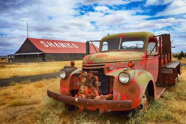
Not an abandoned Portland food truck. | FLICKR/IAN SANE
The history of Central Oregon’s Shaniko looks a little different than most of America’s ghost towns: It wasn’t a mining boom town, but rather a haven for ranchers and an unusually large shipping hub for somewhere so far inland. Once deemed the “Wool Capital of the World,” Shaniko rose and fell incredibly fast.
In 1900, the Columbia Southern Railway was extended to the area, connecting it to other parts of Oregon and surrounding states. Shaniko was officially incorporated in 1901, and that same year the town produced 2,000 tons of wool to service communities along the rail line. Business was steady — one year, wool sales totaled $5 million — until the decade’s end, when a new, more appealing railroad cut Shaniko out of the equation. Around the same time, two fires in the business district destroyed any remaining hype, sending Shaniko on the path toward abandonment only 10 years after its founding.
A very small handful of people still occupy Shaniko, but it’s been officially called a ghost town since the ‘50s. The Shaniko Hotel was — and continues to be — the town’s main attraction. Finished in 1902, it was initially a jack-of-all-trades gathering place, with guest rooms, a saloon, a bank, and a dance hall. Other surviving buildings include the Sage Museum, Shaniko School, city hall, jail, post office, and a wool barn. Businesses along “Shaniko Row” open seasonally for summer visitors passing through, including beloved ice cream shop Goldies.
Sophie-Claire Hoeller and Kastalia Medrano also contributed to this story.